
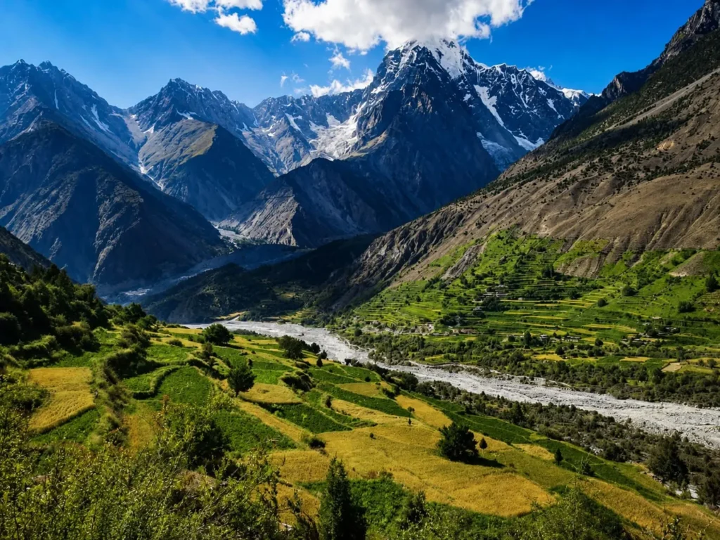
Bagrot Valley is a remote mountain valley located about 25 km south of Gilgit City, known for glaciers, alpine meadows, orchards, and views of Rakaposhi, Diran, and Haramosh peaks.
Where Is Bagrot Valley Located?
If you’re wondering where is Bagrote Valley located, it lies northeast of Gilgit City in Gilgit-Baltistan, Pakistan. Bagrot Valley sits in the Gilgit District of Gilgit-Baltistan, Pakistan. It lies approximately 25 kilometres northeast of Gilgit City. The valley opens from the southern bank of the Gilgit River and extends northward into the Karakoram Mountain Range.
The valley runs roughly 40 kilometres in length from its mouth near the Gilgit River to its upper glacial zones. It is oriented on a north-south axis, with the lower villages sitting at elevations around 2,000 metres and the upper alpine terrain rising well above 4,000 metres.
Bagrot Valley is flanked by the Haramosh Range to the east and the ridgelines separating it from Danyore and Jutial valleys to the west. To the north, the valley terminates near the glaciers feeding the Barchi and Hinarchi glacier systems. Naltar Valley lies to the northwest, while the Gilgit-Skardu Road forms the main southern boundary of the valley’s access corridor.
The nearest urban landmark is Gilgit City, which serves as the primary supply and transport hub for all visitors entering Bagrot Valley. The Karakoram Highway passes through Gilgit, and from there a dedicated valley road branches off toward Bagrot. Diran Peak and Rakaposhi are visible on clear days from the upper sections of the valley, confirming its deep position within the Karakoram and Nanga Parbat Himalayan convergence zone.
Bagrot Valley at a Glance
| Feature | Details |
| Location | Gilgit District, Gilgit-Baltistan, Pakistan |
| Elevation Range | Approx. 1,800 m (valley mouth) to 4,500 m+ (upper glacial zones) |
| Distance from Gilgit City | Approximately 25 km |
| Estimated Travel Time | 45 minutes to 1.5 hours depending on road conditions and vehicle |
| Best Season to Visit | April to October |
| Languages Spoken | Shina (primary), Urdu (widely understood) |
| Main Villages | Hamaran, Sinakar, Datuchi, Bolchi, Farfu, Hopay |
| Accommodation | Limited guesthouses and camping; Sarai Hotel in lower valley; Gilgit City recommended for broader options |
| Road Type | Paved to mid-valley; jeep track in upper sections |
| Permit Required | Not required for Pakistani nationals; foreign nationals should verify current NOC requirements |
How to Reach Bagrot Valley from Gilgit
Route Overview
Bagrot Valley is accessed via a single road that branches off from Gilgit City and follows the Gilgit River before turning north into the valley. The route is straightforward but requires attention to road quality in the upper sections.
Step 1 – Start from Gilgit City Centre
Begin your journey from Gilgit’s main bazaar or the Karakoram Highway junction. This is your last point to fuel your vehicle, withdraw cash, and stock supplies. There are no ATMs or fuel stations inside Bagrot Valley.
Step 2 – Take the Bagrot Valley Road
From central Gilgit, head northeast toward the Gilgit River bridge. The turnoff for Bagrot Valley road is clearly identifiable near the Danyore area. Ask locally for “Bagrot Road” if uncertain. The first segment follows a paved road along the lower valley floor.
Step 3 – Drive Through the Lower Valley
The lower section of the road passes through Hamaran and Sinakar. This stretch is mostly paved and manageable in standard vehicles. Distance from Gilgit to Hamaran is approximately 15 km.
Step 4 – Continue Toward Upper Villages
Visitors travelling deeper into Bagrot Valley beyond Sinakar should expect significantly rougher road conditions. By the time the route reaches Datuchi and Bolchi, the road becomes narrow, rocky, and uneven, making a 4WD or high-clearance vehicle strongly recommended.
Step 5 – Reaching the Upper Valley
For Farfu, Hopay, and glacier viewpoints, a jeep or 4WD is essential. This upper section adds another 15 to 20 kilometres on rough terrain. Allow an additional 45 to 60 minutes beyond the lower valley.
Public Transport
Shared wagons and Suzuki vans operate between Gilgit and lower Bagrot villages. Departures are from Gilgit’s Punial Road transport stand, usually in the morning between 7:00 AM and 9:00 AM. Service is infrequent and not guaranteed daily.
Taxi Options
Local taxis from Gilgit can take you to lower Bagrot villages. Agree on a round-trip fare before departure. Prices vary seasonally; negotiate firmly and confirm waiting charges if you plan to explore.
Private Jeep Hire
Visitors travelling to the upper villages of Farfu and Hopay by jeep should allow approximately 1.5 to 2 hours from Gilgit, depending on road conditions and seasonal factors.
For upper valley access, glacier viewpoints, and trek starting points, hiring a private jeep with a local driver is the most reliable option. Drivers familiar with Bagrot Valley roads are available through Gilgit guesthouses and transport operators.
GPS and Navigation Tips
Mobile data coverage is limited beyond Hamaran. Download offline maps of Gilgit-Baltistan on Google Maps or Maps.me before departure. Mark Bagrot Valley road entry from Gilgit as a waypoint. The valley road does not have multiple branches in most sections, so navigation is manageable with offline tools.
Road Conditions and Driving Difficulty
The road into Bagrot Valley divides clearly into two different driving experiences. Understanding these divisions helps travelers select the right vehicle and manage expectations before departure.
Paved Sections
The road from Gilgit City to the lower villages of Bagrot — approximately the first 15 to 18 kilometres — is paved or semi-paved. This stretch covers the approach road from Gilgit and extends to around Sinakar village. A standard saloon car or hatchback can manage this section comfortably in dry weather conditions.
Jeep Track Sections
Beyond Sinakar, the road transitions into a rough jeep track. From Datuchi onward, the path narrows significantly. Loose gravel, exposed rock, and uneven gradients become standard. The track continues in this state all the way to Farfu, Hopay, and the upper valley glacial zones.
| Road Segment | Surface Type | Vehicle Suitability |
| Gilgit to Hamaran (~15 km) | Paved / semi-paved | Standard car acceptable |
| Hamaran to Sinakar | Paved with patches | Standard car with caution |
| Sinakar to Datuchi | Deteriorating paved | High clearance preferred |
| Datuchi to Farfu/Hopay | Rough jeep track | 4WD essential |
| Upper valley / glacier approaches | Unmaintained track | 4WD jeep with experienced driver only |
Seasonal Road Challenges
Spring snowmelt between March and May creates muddy, waterlogged sections in the upper valley. Summer monsoon rains between July and August increase landslide risk on the hillside-hugging portions of the track. Sections near the river can flood temporarily after heavy rain.
Monsoon and Landslide Risks
The upper Bagrot Valley road runs close to steep hillsides in several places. During monsoon season, falling rock and debris are genuine hazards. Travel during or immediately after heavy rain is not advisable on the jeep track sections. Check locally in Gilgit for current road status before proceeding in monsoon months.
Vehicle Recommendations
A Toyota Land Cruiser, Hilux, or equivalent 4WD with high ground clearance is the recommended vehicle for the full valley route. Suzuki Jimny and similar compact 4WDs can manage most sections but may struggle with the most challenging upper tracks.
Self-Drive Suitability
Experienced off-road drivers can self-drive the lower and mid-valley without difficulty. The upper valley tracks are best navigated with a local driver who knows the terrain. First-time visitors to Gilgit-Baltistan mountain roads should hire a local driver for the entire route.
Can You Visit Bagrot Valley as a Day Trip from Gilgit?
Yes, a day trip to Bagrot Valley from Gilgit is practical for visitors who focus on the lower and mid-valley sections. It is not sufficient for reaching upper glaciers or completing significant treks.
Sample Day Itinerary
6:30 AM – Depart Gilgit Leave Gilgit City early to maximise daylight and beat midday heat in summer. Have breakfast before departure or carry food from Gilgit.
7:15 AM – Enter Bagrot Valley You will reach the valley mouth within 45 minutes. After crossing the Bagrot Valley turnoff near Danyore, the road narrows and follows the Bagrot River between steep mountain slopes.
7:45 AM – First Photography Stop: Lower Valley Viewpoint Stop near Hamaran for an early morning view of the valley corridor. Light is ideal for photography at this hour. Orchard trees in spring are particularly photogenic.
8:30 AM – Drive to Sinakar Village Continue to Sinakar and observe traditional Shina-speaking village life. Walk the village lanes briefly if time allows.
9:30 AM – Proceed to Datuchi and Mid-Valley This section requires a 4WD. Stop at elevated points for views toward Diran Peak and the glacier-capped ridgelines to the north.
11:00 AM – Gargo Meadows Area Spend 60 to 90 minutes exploring the meadow zone and photographing the surrounding peaks. This is the visual highlight for most day visitors.
1:00 PM – Lunch Carry a packed lunch from Gilgit. There are no reliable restaurants in the upper valley. Some local households in Bolchi or Farfu may offer tea if you ask respectfully.
2:30 PM – Begin Return Journey Start heading back no later than 2:30 PM. Upper tracks take longer in the afternoon when dust and reduced light make navigation harder.
4:30 PM – Return to Gilgit Arrive back in Gilgit with time to rest before dinner.
Who Should Stay Overnight Instead
Trekkers heading to Hinarchi or Barchi Glaciers need at least one overnight stay inside the valley. Photographers wanting golden-hour light on the upper peaks need to be in position by early morning. Families with young children and limited hiking experience will benefit from a more relaxed overnight pace rather than rushing the entire route in one day.
Best Places to Visit in Bagrot Valley
1. Gargo Meadows
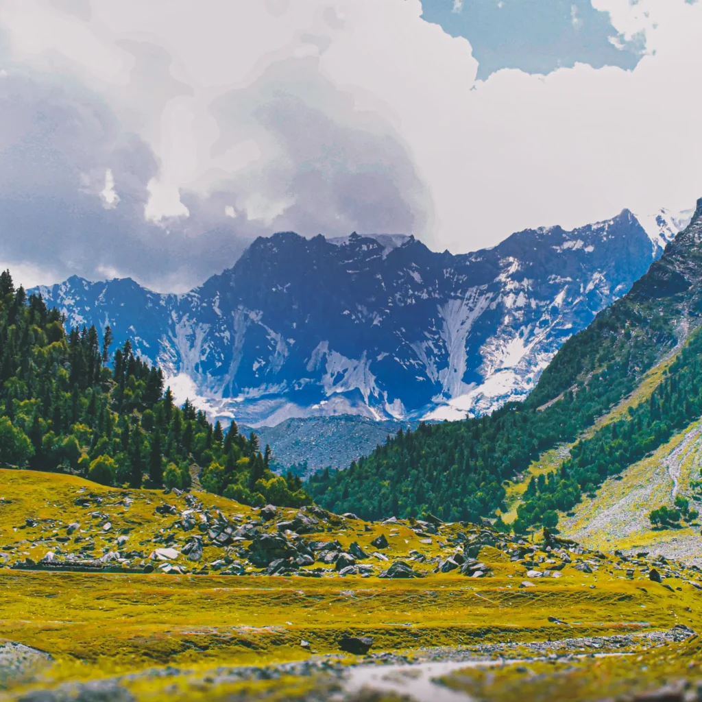
Gargo Meadows sit in the upper section of Bagrot Valley at significant elevation above the main valley floor. The meadows open into a wide alpine grassland surrounded by glaciated peaks. Gargo Meadows is one of the most frequently photographed locations in Bagrot Valley because of its open alpine terrain and mountain views. Wildflowers appear from late May through July. The meadows serve as a base camp area for trekkers heading toward glacier zones. Morning light at Gargo Meadows creates strong contrast on the ridgelines below Bilchar Domani and the upper Bagrot glacier basin.
2. Dobani Glacier Viewpoints
Bilchar Domani — also referenced locally as Dobani — is a prominent peak visible from the upper valley. The viewpoints along the trail toward this glaciated massif offer unobstructed sightlines across multiple glacier tongues. The approach requires a half-day hike from Hopay village, the main trekking base in upper Bagrot Valley. Crampons are not necessary for the viewpoint approach, but proper trekking boots are essential.
3. Barchi Glacier
Barchi Glacier is one of the accessible glacier systems in the upper Bagrot Valley. The glacier snout can be approached on foot from the road head. The trail passes through boulder fields and moraine terrain. Trekking time from the upper road to the glacier snout is approximately two to three hours round-trip. The glacier surface shows visible crevassing in its middle sections — do not walk onto the glacier without a local guide.
4. Hinarchi Glacier
Hinarchi Glacier requires a longer approach than Barchi and typically involves at least one night of camping. The glacier sits in a side valley branching from the main Bagrot corridor. The approach trail passes through high pastures used by Gujjar herders in summer. Views from the upper moraine of Hinarchi include sightlines toward Haramosh Peak. This is a destination for committed trekkers rather than casual day visitors.
5. Orchard Zones — Spring Blossom Season
The lower and mid-valley sections of Bagrot are covered in orchards producing apricots, apples, mulberries, and cherries. In April, the blossom season transforms these zones into a layered landscape of white and pink flowers against brown hillsides. In Hamaran, Sinakar, and Datuchi villages, apricot and cherry blossom usually lasts two to three weeks between late March and mid-April, depending on seasonal temperatures. Visitors arriving in late March or early April should verify bloom timing locally before travelling.
6. Village Viewpoints
Each of the main villages — Hamaran, Sinakar, Datuchi, Bolchi, Farfu, Hopay — sits at a slightly different elevation and offers a distinct angle into the valley. The elevated positions above Bolchi and Farfu provide the best unobstructed views of the lower valley corridor and the Gilgit River watershed. Walking the old footpaths between Sinakar, Datuchi, and Bolchi reveals terrace-farmed slopes, irrigation channels, and traditional stone houses that are often missed from the jeep track.
7. Bagrot River Scenery
The Bagrot River runs along the valley floor and is fed by multiple glacier meltwater streams. The river is most powerful between June and August when glacier melt peaks. Riverside stops along the mid-valley road offer clear, fast-moving water against a backdrop of grey scree slopes and green vegetation. Early morning visits to the riverside catch the mist rising from the cold water.
8. Photography Spots Summary
The most productive photography locations in Bagrot Valley are the lower valley orchards in April, the Gargo Meadows in June and July, the Barchi Glacier approach trail in August, and the upper village viewpoints at sunset in September and October. Carry a wide-angle lens for valley panoramas and a telephoto for isolating glacier detail and distant peak profiles.
Villages of Bagrot Valley
The six main villages—Hamaran, Sinakar, Datuchi, Bolchi, Farfu, and Hopay—are connected by a combination of valley roads, footpaths, and traditional cable-car crossings used in some areas of northern Pakistan.
Bagrot Valley contains six primary villages distributed along the valley floor and lower slopes, each functioning as a distinct agricultural and social unit.
Hamaran sits closest to the valley mouth and is typically the first settlement visitors reach after leaving the Gilgit River approach road. It functions partly as the administrative and logistical anchor of the lower valley.
Sinakar lies further north and occupies a wider section of the valley floor. Farming is intensive here, with terraced fields growing wheat, maize, and vegetables. The village maintains clear Shina-speaking cultural practices in daily life.
Datuchi marks roughly the transition between the lower valley and the mid-valley zone. The road beyond Datuchi becomes noticeably rougher. The village sits on a slight elevation above the valley floor, giving it a broader sightline toward the surrounding ridgelines.
Bolchi is a smaller settlement in the mid-valley zone. Residents here practice a mixed economy of farming and seasonal animal herding. Stone and mud-brick construction is standard in Bolchi, maintaining the architectural traditions common across Gilgit-Baltistan’s mountain villages.
Farfu sits higher in the valley and is one of the last permanently inhabited settlements before the terrain becomes too steep and cold for year-round agriculture. Apricot trees are prominent here and provide both food and income during summer.
Hopay is the uppermost main village in Bagrot Valley. It serves as a starting point for treks heading toward Gargo Meadows, Barchi Glacier, and Hinarchi Glacier. Local families in Hopay occasionally accommodate trekkers when pre-arranged.
Across all six villages, life follows an agricultural rhythm tied to the seasons. Summers are productive with crop cultivation and livestock grazing in upper pastures. Winters are quiet, with households conserving resources during cold months. Community decisions are made through traditional jirga-style gatherings. Hospitality is extended naturally to visitors who approach respectfully and follow local norms.
Mountains and Glaciers Visible from Bagrot Valley
Rakaposhi (7,788 m)
Rakaposhi is visible from the lower sections of Bagrot Valley on clear days, particularly when looking southwest along the valley’s broader sightlines. It is one of the most recognisable peaks in the Karakoram due to its continuous rise from the valley floor without intervening ridgelines blocking the profile. Early morning between 6:00 AM and 9:00 AM provides the sharpest views before haze builds.
Diran Peak (7,266 m)
Diran Peak, part of the Rakaposhi-Haramosh Range, is directly visible from multiple points within the mid and upper Bagrot Valley. It is also known as Minapin Peak. The peak’s glaciated north face reflects light in the early morning, creating strong photographic opportunities from the valley road above Sinakar and Datuchi.
Haramosh Peak (7,409 m)
Haramosh Peak rises to the east of Bagrot Valley. It is most clearly visible from the upper valley terrain, particularly from the high ground above Farfu and Hopay. The Haramosh massif occupies the eastern skyline when looking from Gargo Meadows and the Hinarchi Glacier approach trail.
Bilchar Domani
Bilchar Domani — sometimes written as Dobani — is the peak most directly associated with the Bagrot Valley landscape. It sits within the valley’s own ridgeline system and dominates the upper valley view. At approximately 5,723 metres, it is the most visually prominent peak from within the valley itself.
Glacier Systems
Bagrot Valley hosts multiple glacier systems: Barchi Glacier, Hinarchi Glacier, and several unnamed tributary glaciers feeding the Bagrot River. These glaciers are currently retreating, as documented across Gilgit-Baltistan. The moraines beside Barchi Glacier and Hinarchi Glacier are visible as grey boulder ridges that mark the glaciers’ former extent.
Best Viewpoints and Photography Timing
The best panoramic mountain views are from the elevated ground above Bolchi and Farfu villages, the Gargo Meadows plateau, and the moraine ridges above Barchi Glacier. Golden-hour light strikes the western faces of Diran and Bilchar Domani in the late afternoon between 4:00 PM and 6:00 PM, depending on the season.
Best Time to Visit Bagrot Valley (Month-by-Month Guide)
Bagrote Valley weather varies significantly by season, ranging from heavy snowfall in winter to mild trekking conditions during summer and autumn.
The practical tourism season in Bagrot Valley runs from March through November, although conditions are generally best between April and October
| Month | Conditions | Recommended For |
| January | Heavy snow, road closures possible above Sinakar | Not recommended for tourists |
| February | Cold, snow persists, limited access | Not recommended |
| March | Lower valley accessible, blossom begins late month | Blossom photography — timing uncertain |
| April | Peak blossom season, mild temperatures, full lower valley access | Orchard photography, village visits |
| May | Green landscapes, snow still on upper trails, roads opening | Spring trekking, family visits |
| June | Upper valley accessible, trekking season starts, some rain | Glacier treks, Gargo Meadows |
| July | Monsoon influence, occasional rain and landslide risk | Trekking with caution; rivers high |
| August | Warmest month, glacier melt peaks, high rivers | Full-valley exploration; check roads |
| September | Stable weather returns, autumn colours begin | Best overall month for most visitors |
| October | Golden foliage, crisp air, excellent clarity | Landscape photography, peaceful visits |
| November | Temperatures drop, upper valley closes, transition season | Lower valley only; not recommended for trekking |
| December | Cold, minimal tourism, upper roads inaccessible | Not recommended |
March: Blossom Season
The apricot and cherry orchards in the lower and mid-valley begin blooming in late March. The exact timing shifts by one to two weeks depending on the year’s temperature patterns. Visitors targeting blossom photography should monitor conditions in early March by contacting guesthouses in Gilgit or local contacts in Hamaran. The blossom period lasts approximately 15 to 20 days.
April and May: Spring
April is one of the most visually diverse months in Bagrot Valley. Blossom trees, emerging green fields, and snow-covered upper peaks create strong compositional contrast. By May, snow recedes from mid-valley trails and the first trekkers begin reaching Gargo Meadows. Temperatures are comfortable and the valley is not crowded.
June, July, and August: Trekking Season
The full valley opens for trekking from June onward. Gargo Meadows, Barchi Glacier, and Hinarchi Glacier are all accessible. July and August bring the monsoon influence from the south, which can interrupt travel with sudden rain and the occasional road closure due to landslides. Glacier rivers are at their highest flow during August. Trekkers should carry rain gear and allow flexibility in their schedules.
September and October: Autumn
September generally offers the most stable combination of clear weather, open roads, and mountain visibility in Bagrot Valley. Weather is stable, skies are clear, and the summer crowds in Gilgit-Baltistan begin to thin out. October brings autumn foliage to the orchards and deciduous trees throughout the valley. Poplar trees lining the valley road turn golden in mid-October. Photography conditions are excellent through both months.
November: Transition Season
November marks the end of the practical tourist season in Bagrot Valley. The lower valley remains accessible throughout the month, but temperatures drop sharply after sunset. Upper valley trails are closed by snowfall by late November. Visitors in November should plan for lower valley exploration only and carry warm layering for mornings and evenings.
Winter Road Closures
The jeep track sections of Bagrot Valley road above Sinakar are subject to snowfall closure from December through February. In heavy snow years, even the paved lower sections may become temporarily impassable. Travellers planning winter visits should call Gilgit transport operators in advance to confirm road status.
Culture, Language and Local Life
Because many older residents speak primarily Shina, visitors without Urdu or Shina language skills may occasionally benefit from a local guide or translator. Urdu is widely understood by adult males and is used for communication with visitors from outside Gilgit-Baltistan. English is limited to educated younger residents and those working in the tourism sector in Gilgit City.
The population of Bagrot Valley is predominantly Muslim and follows the Shia tradition, consistent with the broader Gilgit District demographic. Religious observances shape daily routines, particularly during Ramadan and Muharram. Visitors should dress modestly and be aware of prayer times when making requests of local residents.
Traditional houses in Bagrot Valley are built from stone and mud brick, with flat wooden roofs designed to carry snowload. Interior layouts typically include a central hearth room used for winter heating and cooking. Many households have added more recent construction materials to newer sections of their homes, though older village cores retain the traditional architecture.
Farming is the primary economic activity. Wheat, maize, barley, potatoes, and pulses form the staple crop base. Fruit orchards provide seasonal income through apricot, apple, and cherry production. Apricots are dried on rooftops after harvest for winter storage and sale. Livestock — including cattle, goats, and sheep — are moved to upper pastures in summer and returned to village level before the first autumn frosts.
Common agricultural products in Bagrot Valley include apples, pears, apricots, wheat, tomatoes, potatoes, maize, and barley.
Seasonal migration to summer pastures is practiced by families in the upper villages. This pastoral tradition links Bagrot Valley to wider Gilgit-Baltistan cultural patterns. Visitors staying in villages such as Hamaran, Farfu, and Hopay are often invited for tea by local Shina-speaking families, reflecting the valley’s strong tradition of hospitality.Visitors who approach local residents with respect and patience will consistently encounter genuine warmth.
Hotels, Guest Houses and Camping Options
1. Sarai Hotel, Bagrot Valley
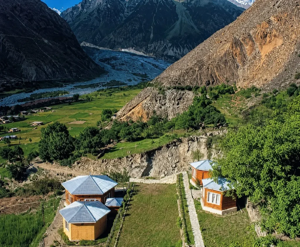
The Sarai Hotel is the most consistently referenced accommodation option within Bagrot Valley itself. It is located in the lower valley section and offers basic room facilities suitable for overnight stays between trekking days. Amenities are simple: beds, blankets, and meals prepared on request. Do not expect WiFi, hot water reliability, or room service at this property. Confirm availability by contacting Gilgit-based travel agents before arrival, as the hotel may operate seasonally.
2. Local Guesthouses
Several local families in villages including Hamaran, Datuchi, and Hopay offer informal guesthouse arrangements, particularly during the summer trekking season. These are not formally listed on booking platforms. Access them through Gilgit-based tour operators or by asking local contacts in the valley. Expect a clean room, shared bathroom facilities, and home-cooked meals. Rates are negotiated directly.
3. Camping
Bagrot Valley offers excellent camping terrain, particularly in and around Gargo Meadows and the moraine zones near Barchi and Hinarchi Glaciers. There are no formal campsites with facilities. Carry a full camping kit including tent, sleeping bag rated for sub-zero temperatures, cooking equipment, and water purification tools. Obtain permission from landowners or community members before pitching camp near village areas.
4. Staying in Gilgit City vs. Inside Bagrot Valley
Gilgit City offers a full range of accommodation from budget guesthouses to mid-range hotels, reliable food options, cash access, and connectivity. For visitors doing a day trip or short valley visit, basing yourself in Gilgit and driving into Bagrot each day is the most practical approach. For trekkers covering Gargo Meadows and the upper glacier zones, at least one night inside the valley is necessary to manage travel distances effectively.
5. Booking Advice
Book any accommodation in advance during the peak season of June through September. Contact Gilgit-based guesthouses or tour operators who have existing relationships with valley hosts. Walk-in availability is possible outside peak months but cannot be guaranteed.
What to Pack for Bagrot Valley
Footwear
- Waterproof trekking boots with ankle support — essential for glacier approaches and rocky jeep track walking
- Camp sandals or lightweight shoes for village walking and rest periods
Clothing
- Moisture-wicking base layers for warm-weather trekking
- Insulating mid-layer fleece or down jacket — temperatures drop sharply at elevation and after sunset year-round
- Waterproof outer shell jacket — mandatory during July and August monsoon months
- Warm hat and gloves — required above 3,500 m even in summer
- Sun-protective long-sleeve shirts — UV exposure is high at altitude
- Warm trousers for evenings
Rain Protection
- Waterproof pack cover for your rucksack
- Dry bags for electronics and documents
Power and Connectivity
- High-capacity power bank — electricity supply in the valley is intermittent
- Universal charging cables
- Offline maps downloaded before departure (Google Maps or Maps.me)
Medical and Safety
- Personal first aid kit including blister treatment, antiseptic, and bandages
- Altitude sickness medication — consult your doctor before travel
- Prescription medications in adequate supply — no pharmacy in the valley
- Water purification tablets or a portable filter — glacier meltwater sources require treatment
Photography Equipment
- Wide-angle lens for valley panoramas and orchard blossom scenes
- Telephoto lens (200–400 mm) for glacier detail and distant peak photography
- Extra batteries — cold temperatures reduce battery performance significantly
- Lens cleaning kit for dust on jeep track sections
General Essentials
- Cash in Pakistani Rupees — no ATMs in Bagrot Valley
- Sunscreen (SPF 50+) and UV-protective sunglasses
- Lightweight trekking poles for glacier moraine terrain
- Reusable water bottles — minimum two litres carrying capacity
Is Bagrot Valley Safe for Tourists?
Bagrot Valley is considered a safe destination for tourists visiting Gilgit-Baltistan. Communities in Hamaran, Datuchi, and Hopay regularly host trekkers and visitors, and hospitality is a well-established part of local Shina culture. Incidents of crime targeting tourists are not a documented pattern in this valley.
Solo Travel
Solo travellers — both male and female — visit Bagrot Valley without reported security incidents. Female solo travellers should apply the same modesty norms observed across rural Gilgit-Baltistan: covered arms and legs, a headscarf when entering villages, and awareness of cultural expectations around interaction with unrelated men. Travelling with a local guide reduces ambiguity in remote upper valley areas.
Family Travel
Families with children can visit the lower and mid-valley sections without difficulty. The jeep track beyond Sinakar is rough and unsuitable for very young children or elderly passengers with mobility concerns. The lower valley orchards, river scenery, and village walks are entirely accessible for family groups.
Road Risks
The main safety risk in Bagrot Valley is the road itself, not the people. Narrow jeep tracks, sheer drop-offs on riverside sections, and landslide-prone hillsides in monsoon season are the genuine hazards. Hire an experienced local driver for upper valley sections. Do not drive the upper track alone at night.
Trekking Precautions
Glacier approaches require preparation. Do not walk onto glacier ice without a local guide familiar with current conditions. Inform your Gilgit guesthouse of your trekking plan and expected return time. Carry communication options — a local SIM card with Telenor or Jazz network (coverage limited above lower valley) and a note of emergency contacts.
Emergency Services
Emergency medical facilities in Bagrot Valley are extremely limited. The nearest hospital is in Gilgit City. For serious injuries or illness, evacuation to Gilgit is the only option. The Pakistan Army and local administration can assist in emergencies, but response times are measured in hours, not minutes. This reinforces the importance of carrying a well-stocked first aid kit and not taking unnecessary risks in remote terrain.
Frequently Asked Questions
Q1: How far is Bagrot Valley from Gilgit City?
The Gilgit to Bagrote Valley distance is approximately 25 kilometres, depending on the destination village within the valley. The drive takes between 45 minutes and 1.5 hours depending on road conditions, the vehicle used, and how far into the valley you are travelling. The lower valley is quicker to reach; upper sections toward Farfu and Hopay add significantly more time due to rough road conditions.
Q2: Can Bagrot Valley be visited as a day trip from Gilgit?
Yes, a day trip is practical for visiting the lower and mid-valley sections, including Hamaran, Sinakar, Datuchi, orchard zones, and some elevated viewpoints. It is not sufficient for reaching Gargo Meadows, Barchi Glacier, or Hinarchi Glacier at a reasonable pace. Trekkers and glacier visitors should plan at least one overnight stay inside the valley.
Q3: What is the best time of year to visit Bagrot Valley?
September and October are the most consistently recommended months for their stable weather, clear skies, and autumn foliage. April is best for blossom photography. June through August is best for glacier trekking, though monsoon rains can interrupt travel in July and August. Winter months from December to February are not suitable for most visitors.
Q4: What languages do people speak in Bagrot Valley?
The primary language is Shina. Urdu is widely understood. English is limited to younger educated residents and those in contact with Gilgit City tourism services. Learning a few basic Shina greetings is appreciated by local residents and strengthens interactions in the village.
Q5: What type of vehicle is needed for Bagrot Valley?
A standard car is adequate for the lower valley to approximately Sinakar. A 4WD or high-clearance vehicle is required beyond Sinakar for the jeep track sections leading to Datuchi, Bolchi, Farfu, Hopay, and the glacier approaches. A locally knowledgeable driver is recommended for the upper valley track, particularly for first-time visitors.
Q6: Is there accommodation available inside Bagrot Valley?
Accommodation inside the valley is limited. The Sarai Hotel in the lower valley provides basic rooms. Local guesthouses in Hamaran, Datuchi, and Hopay offer simple overnight arrangements, usually accessed through Gilgit-based tour operators. Camping is possible in upper valley areas including Gargo Meadows. Most visitors base themselves in Gilgit City and use it as a logistical hub.
Q7: Are there any treks in Bagrot Valley?
Yes, Bagrot Valley has several trekking options. The approach to Gargo Meadows is a popular multi-hour hike from the upper valley road head. Barchi Glacier can be reached in a half-day round-trip from Hopay area. Hinarchi Glacier requires a longer multi-day commitment with camping. All glacier treks should be done with a local guide familiar with current ice and trail conditions.
Q8: What should I pack for a trip to Bagrot Valley?
Essential items include waterproof trekking boots, warm layering for evenings and high elevation, a rain jacket for monsoon months, a high-capacity power bank, cash in Pakistani Rupees, a personal first aid kit, water purification tablets, offline maps downloaded before departure, and sunscreen. Trekkers heading to glaciers should add camping gear rated for cold temperatures and discuss equipment lists with their Gilgit-based guide in advance.
Plan Your Bagrot Valley Trip with Northern Discover
Planning transport, accommodation, and trekking logistics in Bagrot Valley on your own takes time and local knowledge. dev.northerndiscover.com/ offers direct support for travellers heading into Gilgit-Baltistan.
Services available through Northern Discover include 4WD car rentals and private jeep hire with experienced local drivers familiar with Bagrot Valley roads. Custom itineraries are available for day trips, multi-day valley explorations, and glacier trekking routes to Barchi and Hinarchi.
Local guide arrangements can be made for Gargo Meadows hikes, glacier approaches, and village cultural visits. Trek support services cover logistics, camping equipment coordination, and safety briefings for upper valley terrain.
Plan your Bagrot Valley trip with Northern Discover — WhatsApp us at +923419674740 or email northerndiscover.pk@gmail.com