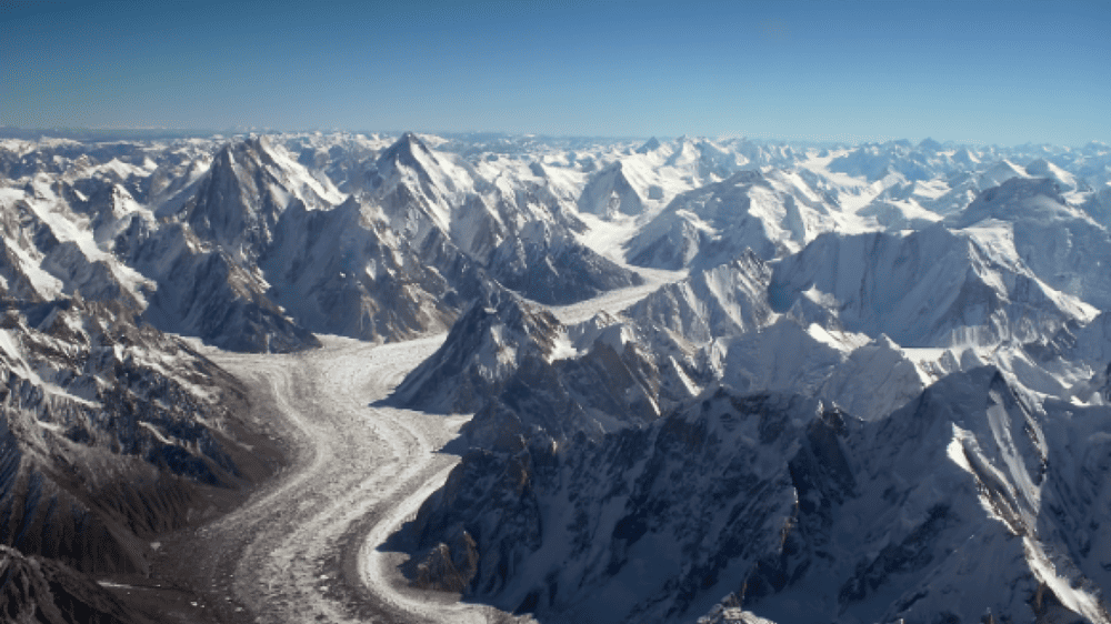
What Happens at 20,000 Feet in Siachen Will Shock You

Have you wondered how to responsibly visit Siachen Valley—the world’s highest glacial region—with essential facts up front? Here’s what you’ll get:
What Siachen is and where it sits
Current access realities from Pakistan’s Gilgit‑Baltistan side
Weather & Siachen Valley temperature guidance
How to plan and pack smartly
A unique angle on Peace Park research & sustainability
What Is Siachen Valley & Where Is It Located?
Siachen Valley refers to the terrain surrounding the Siachen Glacier, stretching roughly 70–78 km in the eastern Karakoram range—making it one of the longest non‑polar glaciers in the world. Its snout lies near 3,570 meters altitude, rising to 6,115 m at Indira Col.
This Siachen glacier system forms the headwaters of the Nubra River, which eventually feeds into the Shyok and Indus rivers in Ladakh (Indian-administered), while the western flanks lie west of the Saltoro Ridge, claimed and partially controlled by Pakistan’s forces.
Why Visit Siachen Valley?
Scientific & strategic interest: The region is geologically and geopolitically unique.
Natural Scenery: A remote high‑altitude landscape unlike any other.
Mountaineering heritage: From early explorers to 1970s Pakistani-permitted expeditions (e.g. Rimo peaks) to Indian-led Himalayan Club missions.
Human dimension: Life around glacier-fed valleys reflects climate adaptation, water-stress and community strength in Gilgit-Baltistan.
How to Reach Siachen Valley (from Pakistan’s Side)
Be clear: Direct access to the Indian‑controlled glacier itself is not permitted from Pakistan. Tourism—or even trekking—into Siachen proper requires an Indian-issued Special Area Permit (SAP) originating from Leh or Nubra Valley communities. But adventurous visitors can:
🚩 Access Permitted Sub‑Ranges
Pakistani side includes glaciers like Chumik, Terong, Rimo, and Gayari sector high posts under Pakistan Army control.
Access through Skardu, using the Karakoram Highway, then permits via the Department of Tourism, Gilgit‑Baltistan. Expedition permits are required for zones above 6,500 m, including some Shaksgam/Baltoro valleys around the Siachen region.
✅ Permit Process (Pakistan side)
Permits issued by Gilgit‑Baltistan tourism, with expedition fees:
Foreign trekkers in restricted zones (above 6500 m): ≈ US$150 per trek
Foreign peak expeditions: US$200 per peak
Nationals: ₹3,000 per person per peak.
Must go through a registered tour operator, insurance, and community protocols.
Practical Route Example:
Fly/drive to Skardu or Gilgit
Travel along the Karakoram Highway to Hushe or Askole
Inquire about local expedition teams for the Terong or Chumik side valleys
Apply for permit with detailed itinerary—processing can take 2–4 weeks.
Siachen Valley Weather & Temperature
The climate is extreme and unforgiving.
Elevations from ~3,500 m to over 6,000 m
Temperatures range from –25 °C by day to –50 °C or lower at night, especially in winter.
Annual snowfall above 1,000 cm at higher altitudes.
Siachen Valley temperature in winter may drop as low as –60 °C during clear nights.
Best time to visit: Short summer window—June to early September—when army‑led trekking batches reach Kumar Base (~5,000 m) from the Indian side; snow bridges are stable, and permit windows open.
Tips, Permits & Safety Warnings
⚠️ Challenges to Know
Altitude sickness: Follow strict acclimatization protocols—cannot rush to 6,000 m.
Logistical isolation: No roads, communications blackout beyond base camp.
Political sensitivity: It’s the highest battlefield; cross-border access needs care.
Environmental hazards: Crevasses and avalanches are deadly—most casualties are weather-related.
✅ Actionable Planning Steps
Confirm permits early: Pakistani or Indian‑side, depending on where you apply.
Acclimatization stays: Plan 3–4 days at Leh (3,500 m), then Nubra / Sumur camps before moving up.
Licensed guides only: Particularly required on Pakistani peaks >6,500 m.
High‑altitude gear: Ensure sub‑zero sleeping bags, solar chargers, layered clothing and crampons.
Waste policy: Pack it in, pack it out—military regulations penalize pollution.
Insurance: Must cover evacuation from >5,500 m.
A Unique Insight: Local Communities & Peace Park Vision
One angle that’s often overlooked is the environmental & research value of Siachen. Scholars and NGOs have proposed a transboundary Peace Park to reduce military costs and protect the fragile ecosystem that supplies water downstream—benefiting both India and Pakistan.
From a Gilgit‑Baltistan perspective, integrating villages in Shigar and Hushe into eco‑tourism, glacier monitoring, and storytelling rooted in Balti heritage is a strong sustainable model. Community‑led trekking around Chumik or Terong valleys offers a lens on glaciology, climate change, and downstream water security—far more engaging than just pushing to touch the glacier snout.
When to Visit & What to Pack
🗓 Suggested Timeline (Pakistani side):
May – Late June: Lower valleys and acclimatization
July – Mid‑August: Side‑valley trekking (Termong, Rimo approaches)
After August, the risk of melt, crevasses, and unstable conditions rises sharply.
Packing essentials:
High-altitude boots, down jacket, balaclava, high‑UV glasses
GPS tracker, satellite phone, or SPOT device
Portable solar charger
Glacier crampons, climbing harness (for expert routes)
First aid kit with altitude meds: acetazolamide, ibuprofen, blister care.
Conclusion
Visiting or researching Siachen Valley can be deeply rewarding if approached thoughtfully—respectful of its harsh climate, sensitive geopolitics, and environmental fragility. With the right permits, gear, and acclimatization, side-valley treks offer unique high-altitude experiences while contributing to community-based awareness and climate research.
Curious about a specific sub‑route like Terong Valley or how to connect with local trekking groups? Comment below with your plans or questions, and I’ll help refine your itinerary or sourcing.
Remember: extreme places demand extreme preparation. Siachen Valley holds unforgettable beauty—just stay smart, respectful, and strategic.
