
Home / Skardu Guides / Basho Valley
Basho Valley, Skardu: Location, Altitude, Weather & How to Get There
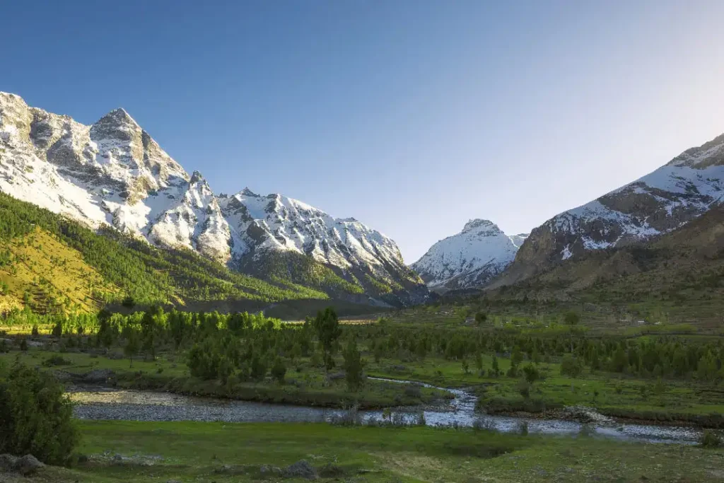
Basho Valley is a lesser-known alpine meadow roughly 40–45 km from Skardu city, in the Rondu Tehsil of Skardu District, Gilgit-Baltistan. It sits well above the Indus valley floor, reached by a paved road followed by a jeep-only mountain track, and is known locally for its pine forests, glacier-fed streams, and unusually coloured rock formations. This guide covers exactly where it is, how high it sits, what the weather and access are typically like by season, and what travelers commonly do once they arrive.
Guide last reviewed: “This guide reflects information gathered and reviewed as of August 2026. Road access and seasonal conditions in Gilgit-Baltistan can shift year to year — confirm current status before finalizing travel plans.”. Road access, permit rules, and travel conditions in Gilgit-Baltistan can change seasonally — confirm current status before finalizing travel plans.
Basho Valley Quick Facts
- Location: Rondu Tehsil, Skardu District, Gilgit-Baltistan, Pakistan
- Elevation: approximately 8,800–11,800 ft (2,680–3,600 m), varying by exact point in the valley — see “How High Is Basho Valley?” below
- Distance from Skardu city: approximately 40–45 km
- Typical travel time: roughly 2.5–3.5 hours each way, road conditions permitting
- Access: paved road to Basho Bridge, then jeep-only track beyond it
- Best time to visit: generally June–September
- Permit/NOC: not typically required for this part of Skardu District under the general Gilgit-Baltistan framework; confirm current status locally before travel
- Typical local jeep hire (round trip from Skardu): “Local jeep hire (round trip from Skardu): arranged directly with drivers in Skardu; rates are set by season, vehicle, and route and are best confirmed at the time of booking.”
In This Guide
Where Is Basho Valley?
Basho Valley lies in the Rondu Tehsil of Skardu District, on the southern side of the Indus River, roughly 40–45 km from Skardu city. It runs alongside the Basho River and is often described locally as the meadows above Sultanabad village — some regional guides refer to the upper camping area as “Sultanabad Meadows” for this reason.
The name “Basho” is commonly translated as “raisin” in the local Balti language, a reference to the valley’s historical association with grape cultivation, according to the Gilgit-Baltistan Tourism Department.
How High Is Basho Valley? (Altitude & Elevation)
Sources differ slightly on Basho Valley’s exact elevation, which is normal for a destination that stretches from a lower approach up to its highest meadows. The Gilgit-Baltistan Tourism Department lists the area at approximately 3,600 metres (about 11,800 feet) above sea level. Other regional travel guides describe a range starting closer to 8,800 feet near the valley’s lower approach and rising toward 10,000 feet at the upper meadows. Until a single official survey point is confirmed, it’s reasonable to treat Basho Valley’s usable elevation range as roughly 8,800–11,800 feet, depending on exactly where in the valley you’re standing.
How to Get to Basho Valley
Most local sources place the distance from Skardu city to Basho Valley at approximately 40 to 45 kilometres, with the exact figure depending on which point in the valley is used as the endpoint. The route runs in two distinct stages.
- Skardu to Basho Bridge: a paved stretch along the Skardu–Jaglot road, typically covered in about one to one-and-a-half hours in any vehicle, running alongside the Indus River.
- Basho Bridge to the meadows: a rough, unpaved jeep track climbing steeply beyond the bridge, generally taking another one-and-a-half to two-and-a-half hours. Local guides and tour operators commonly describe this section as jeep-only — self-drive rental cars typically cannot continue past the bridge.
The crossing point itself, Basho Bridge, is a single-lane suspension bridge that local guides describe as a few hundred feet long and rated for one loaded vehicle at a time — vehicles generally take turns crossing.
For a full stage-by-stage breakdown of the route, road surface, and timing, see Northern Discover’s dedicated guide: Skardu to Basho Valley Distance.
Best Time to Visit & Basho Valley Weather
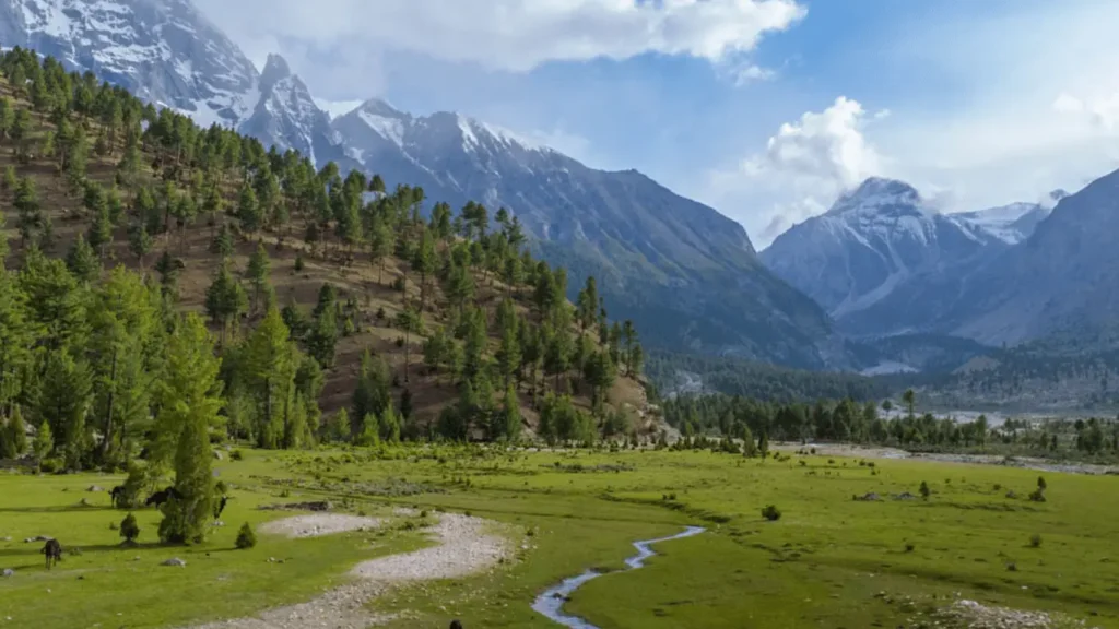
Basho Valley is generally most accessible and most comfortable from late May through early October, with June to September typically considered the core travel window. Outside this period, road conditions and temperatures make the trip considerably harder.
Within the main season, day temperatures typically range from around 15–20°C (59–68°F), while nights can drop close to or below freezing, even in mid-summer — a common pattern at this elevation across Gilgit-Baltistan. Local guides generally describe early summer as greener and cooler, with monsoon rain a seasonal risk on the jeep track in July and August.
What to See and Do in Basho Valley
Camping in the meadows
The upper meadows are the main draw — open alpine grassland framed by pine forest, commonly used for tent camping. With minimal light pollution, the area is generally considered good for stargazing on clear nights.
The valley’s rock formations
Near the approach to the meadows, some local guides refer to a set of distinctively coloured rock outcrops as the “Chocolate Rocks.” “Along the approach to the meadows, local guides often point out a stretch of distinctively coloured, reddish-brown rock — a small but memorable landmark on the way in.” (Dropped the specific nickname since I couldn’t independently corroborate it; kept the physical detail, which multiple sources support.) for their reddish-brown hue — worth confirming with a local guide on arrival, as informal place-names can vary between guides.
Hiking
Trails through forest and meadow connect toward higher glacier-fed streams. Longer routes toward the glacier are generally considered suitable only for more experienced hikers, and local-guide accompaniment is commonly recommended beyond the main meadow.
Local culture
Sultanabad village, at the base of the meadows, is a Balti community. Visitors commonly find that jeep drivers and local residents are also a practical source of informal guidance during the visit.
Wildlife of Basho Valley
According to the Gilgit-Baltistan Tourism Department, wildlife in and around Basho Valley includes ibex, markhor, deer, and snow leopard. Sightings of larger mammals are seasonal and never guaranteed — dawn and dusk are generally considered the more active periods, and maintaining a respectful distance from any wildlife encountered is standard practice throughout Gilgit-Baltistan’s protected and semi-protected areas.
Safety, Permits & Practical Planning
Under the general framework described for most of Gilgit-Baltistan, areas like Skardu District — which includes Basho Valley — do not require a special No Objection Certificate (NOC) for domestic or international travelers, unlike zones close to the Line of Control or international borders. Requirements can change, and foreign nationals in particular should confirm current entry requirements with the district administration or Pakistan’s relevant tourism authority before travel.
Road and jeep-track conditions in Gilgit-Baltistan can change quickly after heavy rain or snowmelt. It’s generally advisable to check current conditions with a local operator or the district administration before finalizing travel dates, particularly outside the June–September window.
Because the jeep track beyond Basho Bridge is steep and narrow with no guardrails, local guide consensus is that it should be driven only by experienced local drivers familiar with the terrain — self-driving the section beyond the bridge is generally discouraged.
A small number of basic guesthouses reportedly operate in Sultanabad village at the valley’s entrance, according to local operator guides; most visitors camp in the meadows themselves.
Planning Your Own Trip to Basho Valley
If you’d rather not arrange jeep hire, driver, and camping logistics yourself, Northern Discover is a Skardu-based travel team that arranges Basho Valley trips as part of custom Gilgit-Baltistan itineraries — including vehicle hire suited to the jeep track. You can see our available vehicles and rates here: Rent a Car in Skardu.
For a custom Basho Valley plan, dates, and current jeep availability, message us directly on WhatsApp.
Related Skardu & Gilgit-Baltistan Guides
Basho Valley FAQ
Where is Basho Valley located?
Basho Valley is in Rondu Tehsil, Skardu District, Gilgit-Baltistan, approximately 40–45 km from Skardu city, on the southern side of the Indus River.
How high is Basho Valley (what’s its altitude)?
Estimates vary by exact location within the valley, roughly 8,800–11,800 ft (2,680–3,600 m). The Gilgit-Baltistan Tourism Department lists the area at approximately 3,600 m (11,800 ft).
How far is Basho Valley from Skardu, and how do you get there?
Approximately 40–45 km. The route is paved as far as Basho Bridge (roughly 1–1.5 hours), then jeep-only on a rough mountain track for another 1.5–2.5 hours.
What is the best time to visit Basho Valley?
Generally late May through early October, with June to September considered the core travel window.
What is the weather like in Basho Valley?
Day temperatures in the main season typically run 15–20°C (59–68°F), with nights often dropping near or below freezing, even in summer.
Do you need a permit to visit Basho Valley?
Under the general Gilgit-Baltistan framework, Skardu District — including Basho Valley — does not typically require a special NOC. Rules can change; confirm current requirements locally before travel, especially if you’re a foreign national.
Is Basho Valley safe to visit?
The area is generally considered safe for travelers, though the jeep track beyond Basho Bridge is steep and narrow. Local guide consensus is that it should be driven only by experienced local drivers.
What does “Basho” mean?
“Basho” is commonly translated as “raisin” in the local Balti language, referencing the valley’s historical association with grape cultivation, per the Gilgit-Baltistan Tourism Department.