
 “A glimpse of the breathtaking mountain landscapes of Gilgit-Baltistan, where majestic peaks meet vibrant valleys”
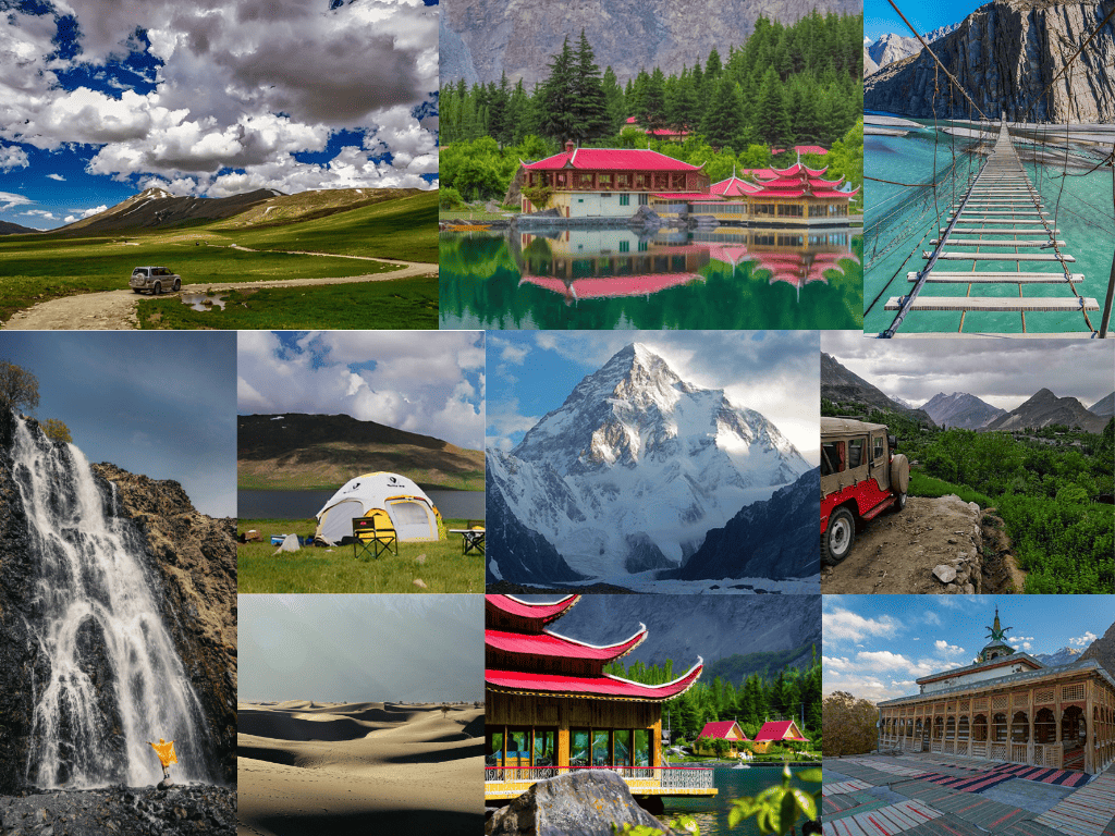
Gilgit-Baltistan is Pakistan’s northern mountain jewel, a region home to over 700 peaks above 6,000m, including K2 (8,611m) and Nanga Parbat (8,125m). Imagine soaring snow-capped peaks, turquoise glacial lakes, and lush valleys at the crossroads of the Karakoram, Himalaya, and Hindu Kush ranges. This guide covers everything tourists and explorers need to know: where Gilgit-Baltistan is, how to get there, the best times to visit, top sights, local culture, and practical tips to make your adventure unforgettable.
Gilgit-Baltistan: Location & Overview
Gilgit-Baltistan lies in northern Pakistan (part of the disputed Kashmir region), bordering China, Afghanistan, and India. It spans roughly 72,496 km² and is almost entirely mountainous. Its capital (and travel hub) is Gilgit, and Skardu is the other major city. The region is semi-autonomous – not officially a Pakistani province – sharing borders with Pakistan’s Khyber Pakhtunkhwa, China’s Xinjiang, Afghanistan’s Wakhan Corridor, and the Indian-administered Jammu & Kashmir.
The population is about 1.7 million (2022 estimate). Locals comprise diverse ethnic groups (Shins, Yashkuns, Balti, Burusho, etc.) and languages. Urdu is the lingua franca, and English is widely used in tourism, but many speak native tongues like Shina, Balti, Khowar, Wakhi, and Burushaski. Islam is universal here (nearly 100% Muslim), with Shia Muslims ~60% and Sunni ~20% of the population. Despite its remoteness, infrastructure is improving (roads, telecom) to support a growing tourism industry.
Getting There: By Road and Air
Gilgit-Baltistan is connected via the Karakoram Highway (KKH) – the world’s highest paved road – and by small regional airports. In summer, you can drive from Islamabad (about 20–24 hours) through Abbottabad and Mansehra, up the scenic Kaghan and Naran Valleys. The KKH (via Chilas) links Pakistan to China; buses (NATCO) run daily from Islamabad–Gilgit and leave from Rawalpindi. For a shortcut (summer only), the Babusar Pass (4,173m) connects Kaghan Valley (KPK) to Chilas and Gilgit – but note this high road closes in winter due to heavy snow. Babusar Pass (4173m) is a summer-only route from Kaghan Valley to Gilgit-Baltistan.
Flying is faster but weather-dependent. Pakistan International Airlines flies Islamabad–Gilgit (50 min) and Islamabad–Skardu (90 min). The Gilgit flight is famously scenic: the plane actually crosses over Nanga Parbat (8,126m)! Note that winter fog and snow often delay flights, so check schedules and book flexibly. If coming from abroad, you’ll first need a Pakistan visa, and often a Northern Areas permit or trek permit for protected zones (check with tour operators or the tourism department).
When to Visit: Weather & Seasons
Gilgit-Baltistan has an alpine climate. Summer (June–August) is the peak season: daytime highs are mild (often 10–15°C, sometimes up to 20°C) and trails are clear. This is ideal for trekking, rafting, and valley tours.
- (Be aware that late July/August can see monsoon rains and Pakistani holiday crowds.)
- Autumn (September–November) offers clear skies, crisp air, and stunning fall colors – a great shoulder season.
- Winters (Dec–Feb) are extremely cold (night temps often drop below –20°C) and many high passes (like Babusar) are snowbound.
Most attractions (e.g., Fairy Meadows, Naran road, Babusar Pass) are closed in deep winter, though winter sports and local festivals take place in Skardu/Gilgit. For safe travel, always check weather forecasts: snow and landslides can block roads in winter, and altitude (Gilgit ~1,500m, Skardu ~2,500m) may cause mountain sickness, so ascend slowly and stay hydrated.
Top Attractions in Gilgit-Baltistan
- K2 & Karakoram Range – Home of K2 (8,611m) and 18 of the world’s 50 highest peaks, Gilgit-Baltistan is a mountaineer’s paradise. The classic trek to K2 Basecamp/Concordia (18–19 days) is legendary. Even if you don’t climb, you can fly or jeep to Concordia viewpoint (Skardu side) and feel dwarfed by towering 8,000m giants.
- Hunza Valley – The jewel of northern Pakistan, Hunza is famed for its historic forts and lakes. Visit Baltit Fort (700 years old) and Altit Fort (1000 years old) overlooking Karimabad. Drive to the village of Passu to see the jagged Passu Cones mountains and walk across the rickety Hussaini Suspension Bridge. South of Hunza lies Attabad Lake, a stunning 21 km turquoise lake formed by a 2010 landslide. Boat rides on Attabad are a popular photo stop.
- Skardu & Deosai – The Baltistan division offers wild, high-altitude scenery. Skardu city is a gateway to the K2/Baltoro region and Deosai Plains (“Land of Giants”), a 4,000m plateau blanketed with flowers in summer. Check out Shangrila Resort (Kachura Lake) and Satpara Lake near Skardu. History buffs can tour Shigar Fort (18th century) and Khaplu Fort. (Most of Deosai and northern Baltistan require 4×4 or jeep permits.)
- Fairy Meadows & Nanga Parbat – Near Gilgit city is the famous Fairy Meadows (reachable by jeep+trek), a lush alpine campground beneath Nanga Parbat’s peak. It’s one of the most-photographed spots, with green meadows and wooden cabins facing the “Killer Mountain.”
- Rock Carvings and History – Along the Karakoram Highway, you’ll find ancient inscriptions and petroglyphs (e.g. the 8th-century Buddha carving near Skardu). Gilgit city itself has bazaars, mosques, and a small Kargah Buddha statue (7th century).
- Pakistan-China Border (Khunjerab Pass) – For a high-altitude road trip, drive north on the KKH to Khunjerab Pass (4,693m, China border). The pass is the world’s highest paved border crossing and offers snowfields and yurts. (Note: entry into China requires permits; otherwise, enjoy the vistas at the customs town of Sost.)
Snowy peaks of the Karakoram Range in Gilgit-Baltistan – home to K2 and many of Pakistan’s highest mountains. - Hidden Gems – Beyond the well-known sites are many offbeat wonders. For example, Khamosh (Khamus) Waterfall in Kharmang Valley is a 60-meter cascade reached by a 2–3 hour hike along the Indus. Don’t miss Fairytale Springs (Kundol Lake) in Kalam, or the remote Shimshal Pass trek area (Wakhi culture). Spending a night in a mountain hamlet can be a highlight – as one traveler notes, locals are so hospitable they’ll even invite you into their home and share a meal.
Hidden gem: Khamosh (Khamus) Waterfall tumbles into a narrow gorge in Kharmang Valley. Reached by a 2–3 hour trek, it’s rewarded by fresh trout streams and roaring cascades.
Culture, Language & People
The people of Gilgit-Baltistan are known for warm hospitality and vibrant traditions. Many villages celebrate local festivals (e.g. Ginani, Jashn-e-Nur) with music and dance. Traditional dress includes colorful woolen caps, pattu shawls, and embroidered robes; in summer, apricot-picking festivals fill the air with sweet scents. Linguistically, Urdu/English serve as common languages, but you’ll hear Shina in Gilgit/Chitralia areas, Balti in Baltistan, Khowar in Ghizer, Wakhi in northern Hunza, and Burushaski in Hunza/Nagar. Almost 99% people practice Islam, with a notable 60% Shia Muslim population. Daily life often centers around agriculture (apricots, wheat, barley) and animal herding.
Based on travelers’ experiences, local hospitality is unmatched: families often insist guests take tea or meals, and it’s customary to offer a small gift of thanks. (One visitor humorously shares that he “hid” a tip under a cushion when the family kept refusing it.) Major towns like Skardu and Gilgit (Hunza) have hotels, restaurants, and ATMs, but in mountain villages you may stay in basic guesthouses or homestays. Pakistani Rupees (PKR) are used throughout. Tipping isn’t expected by most locals, though guides and drivers appreciate it.
Travel Tips & Challenges
- Permits & Security: Obtain all necessary permits before trekking or entering sensitive zones (e.g., climbing permits for Gilgit-Baltistan, a registered tour with the tourism department). Gilgit-Baltistan is generally safe for travelers, but keep abreast of the news. In August 2025, for example, local traders blocked the
- Karakoram Highway for weeks over tax disputes – an extreme case. Such protests are rare, but they highlight that regional politics can affect travel. Always check road conditions (landslides or weather) and follow advice from local authorities or tour operators.
- High Altitude: Even Gilgit city sits ~1,500m above sea level; many destinations are 3,000m+. Acclimatize slowly to avoid altitude sickness. Drink plenty of water and avoid heavy exercise the first day. Keep warm clothing handy, as mountain nights can be very cold year-round.
- Accommodation & Food: Cities and bigger towns have hotels and restaurants, but options are limited in remote areas. Pack a basic first-aid kit, warm sleeping bag, and sturdy boots if trekking. Try local foods like chapshuro (minced meat pie), balti gosht (stew), and dried apricots. Drinking water may need to be treated – stick to bottled water or boiled sources.
- Connectivity: Mobile networks (Ufone/Jazz) cover major towns; data can be patchy on mountains. Download maps and guides in advance. Electricity is mostly reliable, but carry a power bank in case of outages.
- Packing: Layers are key – days may be sunny, nights freezing. Include a warm jacket, hat, sunscreen, and sunglasses (snow glare is intense). In mosques and villages, dress modestly (cover shoulders/knees).
- Local Etiquette: Greetings and hospitality are courteous. Accepting tea or food when offered is polite. Photography is usually welcome, but ask permission before photographing people or military areas (bridges, customs posts).
Conclusion
Gilgit-Baltistan is a treasure trove of adventure and culture. Whether you’re trekking to the foot of an 8,000m peak, cruising on a sapphire lake, or simply enjoying the hospitality of mountain villagers, this guide has given you the essentials: the region’s geography, how to get there, when to go, and what to see. Remember the unique tips above (like acclimatizing gradually and checking travel advisories). Now you’re ready to start planning your journey to Pakistan’s remote northern frontier!
Ready for your own Gilgit-Baltistan adventure? Share your travel plans or past experiences in the comments below. And if you found this guide helpful, consider sharing it with fellow travelers or subscribing for more tips on Pakistan’s spectacular destinations.
Frequently Asked Questions
1. Where is Gilgit-Baltistan?
Northern Pakistan, in the Himalaya–Karakoram region. It borders Afghanistan, China, and India and lies north of Khyber Pakhtunkhwa.
2. What is the capital of Gilgit-Baltistan?
The capital of Gilgit-Baltistan is Gilgit. Skardu is the largest city in the Baltistan division.
3. How many people live there?
About 1.7 million (2022 est.). Its multilingual population speaks Urdu (lingua franca) and local languages like Shina, Balti, Burushaski, Wakhi, etc.
4. What is the area?
Around 72,500 km² (about the size of Ireland).
5. Is Gilgit-Baltistan a province of Pakistan?
Not exactly. It has a semi‑autonomous status and is not constitutionally a province. (The government has announced plans for full provincial status, but it remains administratively separate.)
6. What are popular attractions?
Highlights include K2 and the Karakoram peaks (trekking near Concordia), the scenic Hunza Valley (Baltit/Altit forts, Attabad Lake, Passu Cones), Skardu (Deosai Plains, Shangrila Resort), and Fairy Meadows at Nanga Parbat. The Khunjerab Pass (Pakistan–China border) is also a famed photo spot.
7. What is the climate like?
Summers are cool (daytime avg ~10–15°C) and pleasant for travel. Winters are harsh (night temps can drop below –20°C). Snow often blocks high roads in winter, so many travelers visit in late spring through autumn.
8. When is the best time to visit?
Generally, June–August for trekking, though August is busy. October–November offer beautiful autumn scenery. Spring (April–May) brings wildflowers, but higher passes may still be closed.
9. Is Gilgit-Baltistan safe for tourists?
Yes – it’s one of the safer regions in Pakistan. However, stay informed: e.g. in August 2025, local protests temporarily closed the Karakoram Highway. Always follow local advice and avoid political rallies. Standard travel precautions (especially in remote areas) are advised.
10. What currency is used?
Pakistani Rupees (PKR). ATMs are available in major towns (Gilgit, Karimabad, Skardu). Credit cards are rarely accepted outside city hotels.
11. What is the Independence Day of Gilgit-Baltistan?
Nov 1 is celebrated locally as Gilgit-Baltistan Independence Day (marking accession in 1948).
12. What is the literacy rate?
Around 72% (the highest in Pakistan). This reflects a strong emphasis on education in cities and Gilgit-Baltistan’s numerous private schools.
13. How can I travel to Gilgit from India?
(For information only) Indian nationals need a Pakistan visa and generally cannot enter Gilgit-Baltistan directly due to the disputed status. Most international visitors fly into Pakistan’s main airports (Islamabad, Lahore, Karachi) and then travel by road or flight to Gilgit.
14. What is the main language?
Urdu (the national language) and English are widely understood. Major local languages include Shina, Balti, Burushaski, Khowar, and Wakhi.
15. What are common foods?
Staples include wheat bread, lamb or beef stews (balti gosht), apricot leather, and dairy from yaks and goats. Don’t miss local sweets like walnut halwa.
16. Why visit Gilgit-Baltistan?
It offers unparalleled mountain scenery – home to K2 and other “eight-thousanders” – along with a unique culture, hospitable people, and thrilling adventure (trekking, rafting, mountain biking). Its beauty and remoteness make it a bucket-list destination.